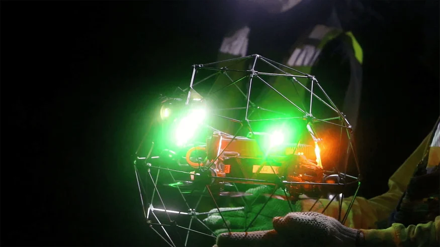
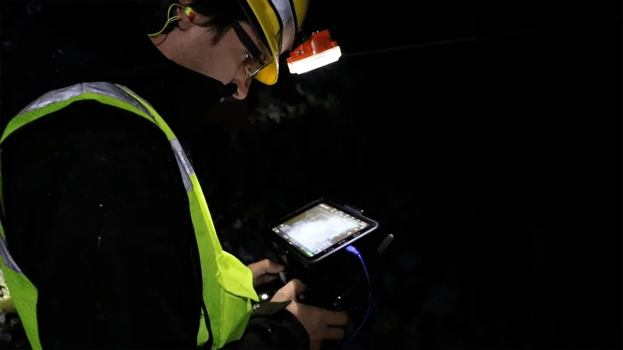
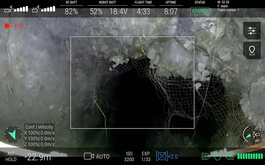
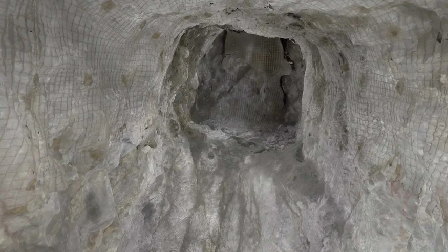
Drones have become a common tool in the mining industry for mapping open-pit mines, but exploring underground spaces remains a significant challenge. The Elios 2 is designed to tackle this issue head-on, offering a cutting-edge solution that brings photogrammetric capabilities into the dark, GPS-denied environments of underground mines. Safety By capturing visual data from dangerous areas, the Elios 2 enables safety assessments that were once impossible, allowing inspections in no-go zones without risking worker safety underground. High Quality Data The drone delivers high-definition 4K video and sharp images, providing critical insights for operations, engineering, surveying, and safety teams during mine development. Ease of Use Its stable flight and durable caged design make it ideal for thorough inspections, minimizing the risk of crashes in tight or hazardous spaces. For three days, Flyability’s Elios 2 was tested at Barrick Gold Corporation’s Golden Sunlight Mine in Whitehall, Montana. This compact drone, specifically built for confined space inspections, proved its worth in some of the most challenging underground conditions. As an advisor to Flyability during the development of the Elios 2, Matt Mackinnon of Unmanned Aerial Services, Inc., aimed to showcase how the drone could enhance mining operations by improving safety and access to critical visual data. “The drone’s stability, its ability to lock distance, and the image quality all exceeded our expectations,†he said. “It checks nearly every box needed for effective underground mining inspections.†Using data collected by the Elios 2, Mackinnon and the Flyability team created a detailed 3D photogrammetric model of a stope—a large volume left after ore extraction. This data helps mining personnel assess the condition of the area, identify loose materials, and locate remaining ore or geotechnical features. After blasting, large rocks can remain suspended inside a stope, posing a serious risk. These rocks can fall unexpectedly, damaging equipment and endangering workers. Traditional inspection methods are limited—either lowering a camera from above or using a pole-mounted camera, both of which offer only partial visibility. This lack of visual data can lead to costly mistakes, including leaving behind valuable ore or losing production due to waste material mixing with the ore. It also puts expensive machinery like muckers at risk of damage. Barrick Gold wanted to gather enough visual data to create a precise 3D map of a stope, ensuring safety, protecting equipment, and maximizing ore recovery. [Related read: What is a LiDAR drone?] High-quality visual data would help the team identify overbreak, fractures, and other geological features that could lead to collapses. This information is crucial for conducting accurate stability analyses and risk assessments. The Elios 2 was deployed across several stopes at the Golden Sunlight Mine. Ryan Turner, a geotechnical engineer at Barrick, worked alongside Matt Mackinnon and the Flyability team to conduct these inspections. “The Elios 2 is safe to use, easy to fly, and its cage protects both people and equipment,†Turner noted. “It’s a reliable tool for navigating harsh underground environments.†The Elios 2 successfully navigated large spaces and tight shafts, capturing high-quality data that was more comprehensive than previous physical inspections. Its lighting system provided sufficient illumination, and the protective cage ensured the drone remained intact even when colliding with wires and bolts. The drone revealed how much material had mixed into the ore and captured detailed images of geological structures releasing material. This data allowed Turner to perform accurate stability analyses and risk assessments. “The imagery looked really good,†he said. “We could see exactly where the structures were releasing material.†The Elios 2 also provided important insights into the position of large boulders and the condition of loose material near mucker operations, helping determine if workers and equipment were at risk. Even first-time users found the Elios 2 easy to fly. A geologist and a mucker operator, both new to drones, controlled the device without issues. This ease of use is rare in underground mining, where many drones tend to crash and get lost. Over three days, five Elios 2 drones were flown without any losses, proving their reliability in extreme conditions. “You can hand it to someone who’s never used it before, and they’ll be successful,†Turner added. In addition to real-time visual data, the Elios 2 collected enough information across four flights to generate a 3D photogrammetric model of a stope using Pix4D Mapper. These models provide a snapshot of the site’s condition and reveal the full volume of the excavation. Geotechnical engineers like Turner use them to compare before-and-after scenarios, track rock movement, and guide decision-making about future operations. Inspectors can click on specific points in the model to view original images and analyze geological features. This helps identify potential risks and supports detailed engineering and geological planning. The Elios 2 has transformed how Barrick Gold and UAS Inc. approach underground mining. With this drone, they can now safely access previously unreachable areas and collect vital data for informed decision-making. The 3D photogrammetric models generated by the Elios 2 will support ore control, stope reconciliation, and hazard identification, ultimately enhancing safety and reducing operational risks. It also helps protect valuable equipment and minimize financial losses due to ore dilution or damage. This article is part of a series on photogrammetry: Bag Parts,Stainless Steel Luggage Ring Parts,Luggage With Small Metal Buckle,Stainless Steel Luggage Triangle Buckle Dongguan New Decoration Material Technology Co., Ltd. , https://www.xsjmim.comMining Drones: Elios 2 Creates Photogrammetric Models
Key Benefits at a Glance
Introduction
Customer Needs
Solution
Results
Photogrammetric Mapping—In Testing And Development
Conclusion